In Via dei Fori Imperiali there is a building next to the beautiful church of Saints Cosmas and Damian (to visit!) which has a very curious holes, arranged in a symmetrical pattern.
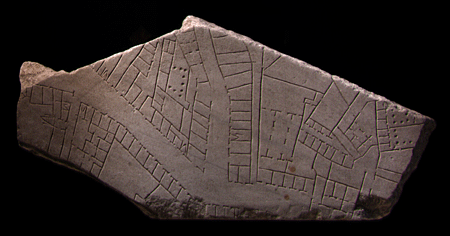
On this wall there was a giant map of Ancient Rome, the Forma Urbis, large 13 x 18 meters .
It was the ancient cadastral database of properties in Rome, engraved on marble slabs. All the population could see and admire the map.
It is thought that it was a hard copy in case of fire or other damage. It was the copy that would not be damaged.
For centuries, only 1186 of the original fragments were recovered. This is only 1/6 of the entire surface.
Below there is a link to the website of the Stanford University where you can see the found fragments.
http://formaurbis.stanford.edu/
No comments:
Post a Comment